Spring Methow-area trip

I recently made a trip to the Methow area to hike and camp and get out of my house. It is a bit early for most trails, I went up the Twisp River road to War Creek but could not drive to the trail head because of snow. I did walk for a couple of hours along the Twisp River trail that parallels the road. It wasn't very exciting but was enjoyable. I liked the many mule's ears blooming along the trail and visible even from the road.
I decided to shift to the Chewuch River road thinking I would find less snow there and more access to trail heads. I drove to the end of the road where a new foot/horse bridge gives access to the trails that used to be at the thirty mile trailhead. I had hiked these trails a few times before the Thirty Mile fire and this was the first time I had gone to the end of the road. I only walked a short ways, the destruction caused by the Thirty Mile fire and the lack of any greenery yet this year made the area very depressing especially as contrasted with what I remember from before. Not to be too self-absorbed, but just didn't want to be there remembering the lives lost and the destruction due to human negligence.


I was lucky enough to see a pair of common mergansers in the Chewuch River near where I camped. I wish I had a telephoto lens for my camera but at least I can tell what I took a picture of, a better outcome than many of my pictures.
I did limited hiking on this trip but I really enjoyed getting out of my house and into the backcountry. Even though the weather was very nice, I saw few people along either river and no other hikers.
Labels: North Cascades hiking
Deception Creek, Alpine Lakes Wilderness
Over the weekend I hiked along the Deception Creek trail. Unlike many of the trails into the Alpine Lakes Wilderness area it is relatively lightly traveled, probably because there are no lakes within easy day hiking distance. I was only able to hike in about 2.5 miles because the bridge across Sawyer Creek was down.
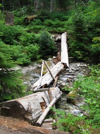
While I was at the bridge, 2 men were working on rebuilding it. Extensive trail work, removing downed trees and building up wet areas, had been done this year on the first 2 miles of trail. By next year, this should be a very nice trail indeed if windstorms and floods do not remove the improvements.

This is a good summer hike through old-growth forest but not usually wet. I saw lots of bunch berries in bloom.
I liked this bridge over Deception Creek about 1/2 mile from the trailhead.

And the view from the bridge:

Besides myself and the 2 men working on the bridge, I saw only 1 set of backpackers who camped just before the downed bridge. There were a few mosquitoes but not many and few flies. The weather was dry with alternating sun and clouds and cool enough that hiking was very pleasant. I'm looking forward to hiking this trail again once the Sawyer Creek bridge is repaired.
Labels: North Cascades hiking
Wenatchee hikes
Over the Labor Day holiday I took 2 hikes in the Wenatchee National Forest, north of Lake Wenatchee. Since rain was forecast for the Seattle area, I wanted to go to the drier area east of Steven's Pass. On Saturday, I hiked up Estes Butte to the old lookout site. This trail is short but goes up 2900' in less than 3 miles. I've hiked it before, the last time the trail had just been re-routed to make it less steep but longer. Sunday I hiked to lower Twin Lake from the White River valley, and ate lunch at the old Forest Service cabin, seeing only 1 other group of hikers. Both days I saw mule deer, not yet very wary of people.
I was surprised to see so few hikers on the trails, along the Chiwawa and White River valleys below there were many campers and lots of vehicle traffic. In the Chiwawa, there were lots of off trail bikers noisily infesting the roads and motor trails. I also saw some "hunters" (sneer quotes intended) driving slowly along roads looking for game. The deer archery season and the black bear season is now open and I was careful to wear bright clothing and cap. I don't have an objection to hunting but have little respect for those who think hunting is driving along a road.
Even at the higher elevations, it isn't fall yet, only the mountain ash is beginning to turn. Mostly the sky was clear and deeply blue. Saturday night only got down to about 50 at 3200' elevation. I remember other Labor Day weekends that I experienced frost even along the valley floors. While a couple of years doesn't prove a warming trend, records do indicate the season between frosts is growing longer in the North Cascades. Fortunately most of the annoying bugs were far fewer than 2 weeks ago, I only saw 1 mosquito and no small black flies. Lots of hornet and bumblebees but they didn't bother me except when eating.
I drove home after my hike on Sunday wanting to avoid the crowds coming home on Labor Day. The Monroe Evergreen State fair was winding up and I knew there would be lots of traffic there. Next weekend I head for Yellowstone National Park, I hope the area gets rain and the thunderstorms let up.
Labels: North Cascades hiking
Snowy Creek, Rainy Pass trail
Last weekend I decided to try the newly constructed Rainy Pass trail on Nason Ridge. I started up from the Snowy Creek trailhead and about a mile in, turned right on the Rainy Pass trail. A new post, presumably for the trail sign, was at the junction. Unfortunately, the Rainy Pass trail was very steep and being mostly unused and probably still being constructed, was slippery and hard to hike. I don't think I went a half a mile before I gave up as dangerous and not much fun. The pine needles and moss made keeping my footing difficult on the steep slopes. I am surprised that the trail was so steep, I'm used to constructed trails, as opposed to scrambles created by fishermen or animals, to be less steep.
I continued along the Snowy Pass trail and ate lunch at the meadow about 3 miles in. Surprised that no one was camped there, it is a great place to backpack to with plenty of room to camp and fresh water. I continued toward Rock Mountain until about the treeline when I decided to turn around. Back at the meadow I spotted a mountain goat on the cliff and spent about 10 minutes watching it and having a snack. Many people have mentioned seeing the goats along Nason ridge trails, I had not previously seen any there in several trips to various points along the ridge, even Alpine Lookout which is well known as a goat hangout. I also heard some large animal, probably a deer, crash through the woods as I re-entered the forest. I saw only 2 other groups on the trail, surprising for an August weekend.
I had an odd experience driving to the trailhead. I was driving on Highway 2 a few miles east of Steven's Pass when I wanted to make a left turn to the Smithbrook access Forest Service road. Highway 2 in this area is a 4 lane, divided highway but is not limited access. The left turn is legal and marked with signs. As I approached it, I moved to the left lane, slowed down, and signaled well before the turnoff. A driver was coming up fast in the left lane and did not like me turning, he pulled to the side and started gesturing at me as I turned. I don't know why he felt that way, the right lane was completely clear and all he had to do was move right. I didn't stay to find out.
Labels: North Cascades hiking
Recent hikes
I have done a few local trails recently and enjoyed mild weather. A couple of weeks ago I hiked to Heather Lake in the
Wenatchee National Forest, not the closer Heather Lake on Mt.
Pilchuk. I was a bit surprised at how few hikers were there on a weekend, 1 pair spent the night there and I met 2 groups coming down. This is a popular and heavily used trail, perhaps the rainy weather caused people to stay home. It didn't rain while I was on the trail and the cooler day was nice for hiking. Very scenic at the lake with patches of snow on the surrounding hills.
Last week I hiked up Tunnel Creek, near Steven's Pass, to the Pacific Crest trail and then south to Trap Lake. Many hikers going up but most probably went north as I only met 1 hiker after I left Hope Lake. This was an extremely clear and nice day, cool enough to enjoy hiking and not many bugs. I saw patches of snow at the passes but none on the trail. Tunnel Creek is one of my favorite ways to access the PCT, a moderately steep 1.5 mile trail connects at Hope Lake and passes other beautiful alpine lakes.
Labels: North Cascades hiking
PNW trails and storm damage
I've been hiking the local trails since April this year, mostly in the Cascade Mountains near Highway 2. I have seen a lot of trail and road damage from last winter's windstorm and flooding. Several trailheads are inaccessible because the access roads washed out. After a couple of detours, I found that Washington Trails Association's website had a more up-to-date list of status than the Forest Service sites (
storm damage). I've been surprised and pleased at how quickly the Forest Service has done the simpler kinds of road and trail maintenance. Of course other groups also do trail maintenance, notably the Washington Trails Association, the
Student Conservation Association, and the
Mountaineers, and are working hard to repair trails. I feel guilty because I don't volunteer for trail maintenance work although I do donate money. I have several reasons, at this point the most relevant being my health.
Many trails are inaccessible and the roads won't be repaired soon. Some of the roads have washed out before, I remember at least once before the Index-Galena road washed out and was inaccessible for years. Some roads should be abandoned but many serve popular areas and probably should and will be re-opened. I hope when the most damaged roads are rebuilt they are rerouted to minimize future chances of washout.
I don't have a real point here except that damage occurred and groups are working to repair the damage. Various governmental fees and taxes as well as non-governmental organizations provide the financial means. My Forest Pass fee (actually I get the Interagency Annual Pass, formerly called the Golden Eagle) seems reasonable given the amount of money required. And there are many users of the forests besides hikers, some of whom pay fees and some do not so I think it is reasonable for general tax revenue to be spent on maintenance.
Labels: North Cascades hiking
Trip Report - Twisp Pass trail
October 21st was a great day to hike the Twisp Pass trail
(http://www.fs.fed.us/r6/oka/recreation/rog/twisp.html) . Once up on Lincoln butte, I had great views of the peaks and meadows. The day was clear and bright with fall colors at their peak. I met a few other hikers including 2 backpackers who were headed for Dagger Lake and 2 hunters. I didn't see any game probably because it was hunting season. At the pass, I climbed part way up Lincoln butte for some pictures of Dagger Lake and peaks to the north. This was the last weekend this year before snow started falling in higher elevations.
Labels: North Cascades hiking
Trail killings near Pinacle Lake
This summer 2 women hikers were shot on a popular Seattle area trail to Pinacle Lake,
http://seattletimes.nwsource.com/html/localnews/2003302372_hikerdeath13m.html. I have been on this trail and in the general area several times, although not recently. For the first couple of weeks after the killing I was more vigilant on the trail but soon stopped thinking about it while hiking. I suspect being more watchful did not make me safer, just anxious. I'm not sure what I can do to protect myself other than hiking in a group, something I don't want to do, see previous post on hiking alone. Besides, since no motive is known group hiking may not be safer.
I know that violent encounters in the backcountry or on trails are rare and I am probably safer hiking than walking around Seattle. Yet this killing seems more real to me than the average shooting in Seattle. I can better relate to the circumstances. I haven't stopped hiking since the killings and won't although I'm not sure I will hike alone in the area where they died for a while.
Labels: North Cascades hiking


